The aim of the Eddleston project is to assess the impact of restoring natural features and processes on both flood attenuation and the ecology of the river, and also to provide empirical evidence with which to assess the effectiveness of the measures implemented. At the same time, a key element is to work with landowners, farmers and the local community so as to maintain the sustainability of land management at all times.
The project, funded by Scottish Government, along with contributions from other public and private sources, including EU Interreg funding has developed in three phases, summarised below:
2009/10: Scoping study, led by Dundee University in conjunction with cbec, which identified a range of potential NFM and habitat restoration measures that theoretically, could be introduced in the catchment; as well as developing a monitoring strategy suitable to assess potential changes.
2010/2011: Installation of a monitoring network by Dundee University comprising: 12 stream gauges, 1 weather station and 4 rain gauges; plus groundwater and fine sediment monitoring (BGS), hydro-morphological and ecological surveys (SEPA, cbec Ltd. and Dundee University). These networks have been greatly extended as the project has developed.
2012/ongoing: Implementation and monitoring of NFM measures
In order to achieve results on the ground and be able to implement measures, community engagement and land manager “buy-in” was (and still is) critical. Much of this has been achieved by the Tweed Forum acting as a trusted intermediary, exploring opportunities and reducing the administrative burden on land managers willing to implement NFM measures. Feedback to local communities has also been importnat throughout.
With the co-operation of many individual farmers, and land managers, the project partners have implemented the following measures on 21 different farm units:
• 207 hectares of newly planted woodland, with over 3300,000 native trees (including oak, ash, willow, birch, aspen and hazel). Trees increase landscape roughness, increase transpiration, increase infiltration and slow down overland flow. Planting has taken place in headwaters and gullies, on floodplains, (most extensively on the Shiplaw and Longcote Burn but also, bankside at Lake Wood, Shiphorns and Cringletie) and also as transverse hedging (2.5km).
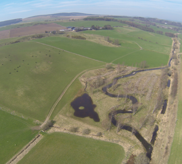
• Created 36 upstream off-line temporary flood storage ponds (~8155m2) increasing flood water storage capacity and delaying and flattening the flood peak. Most of these are in the upper catchment, and in addition two larger ponds have also been created on the floodplain itself, providing both biodiversity enhancement and flood reduction.
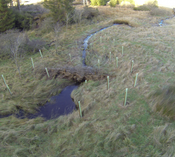
• Constructed 115 large woody structures with the purpose of holding back water in high flows and delaying the flood peak by encouraging spillage onto the floodplain and inducing in-channel sediment deposition (i. e. aggradation). These structures have been formed from the most appropriate materials to the individual sites, for example at Middle Burn, nearby conifers were felled and pinned across the channel. Large root wads and trunks were used at the Craigburn drained upland mire site.
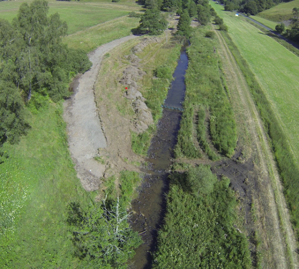
• Re-meandered 3.5km of channel on the main stem of the river, removing flood bank protection and enabling a reconnection between the river channel and the floodplain, in order to slow the flow of water and enable spill over onto the flood plain.
In addition, general good practice is encouraged throughout the catchment, for example; the fencing off of water courses to reduce poaching by livestock and additions of fine sediments. SEPA have recently also visited many of the farms to encourage adoption of Best Practice. The water body has gone from bad ecological status to good ecological potential status under WFD classification.
Analysis of monitoring data is on-going, with a series of recent published papers (Spray et al 2022; Black et al 2021; Hankin et al 2021; Peskett et al 2021) as well as earlier ones (O'Dochartaigh et al 2019; Archer et al 2013) and the comprehensive Study Report - Eddleston Water 2021.
Findings so far include:
• Empirical evidence shows that the timing of peak flow at sites with large woody debris structures is substantially delayed when compared to sites without structures, for catchments upto at least 25km2. Modelling shows that a reduction in peak water level and delays in predicted travel time of flood peaks occur at flows of 1:5 years and above.
• Measurements of water levels show that ponds in the upper catchment can readily store water, but modeling suggests this will only have a relatively small effect on total sub-catchment runoff at this scale. Initial modeling of the potential impact of a series of larger ponds on the floodplain suggests that, for a 1.5-year return interval flow event, such ponds could theoretically locally reduce the discharge peak.
• The remeandering of the previously-straightened channel alone leads to only a limited increase in flood attenuation. For further impact, removal of flood embankments and reconnection to the floodplain is essential. However habitat variability and associated aquatic macroinvertebrate species richness have increased in re-meandered sections, and ecological diversity has returned to pre- intervention levels and is expected to exceed this (continued monitoring will determine if this is the case).
•Soils under mature broad leaved woodland have a much higher permeability (5-8 times)) than those under neighbouring grazed pasture. Soils under coniferous forest have a similar permeability to that of the grazed pasture, however processes such as interception and evapotranspiration, and shading effects on snow cover, will contribute to the delay or reduction of flood peaks.
Other work has explored changes in the delivery of ecosystem services over fifty years, the added biodiversity benefits of creating flood-storage ponds and the net cost benefits of NFM measures in terms of flood damages reduced downstream and the delivery of other ecosystem services and benefits, including water quality, biodiversity, carbon management and recreational benefits. Ongoing work is investigating the importance of antecedent soil conditions on floods and details of the effectiveness of ponds in sub-catchments.of different sizes.